

Prefer a conversation?
Our team is always available to guide you through the process and ensure your experience is perfectly matched to your preferences.
Our team is always available to guide you through the process and ensure your experience is perfectly matched to your preferences.
Duration
18 Nights
Price
From $31,050
Ship
Silver Endeavour
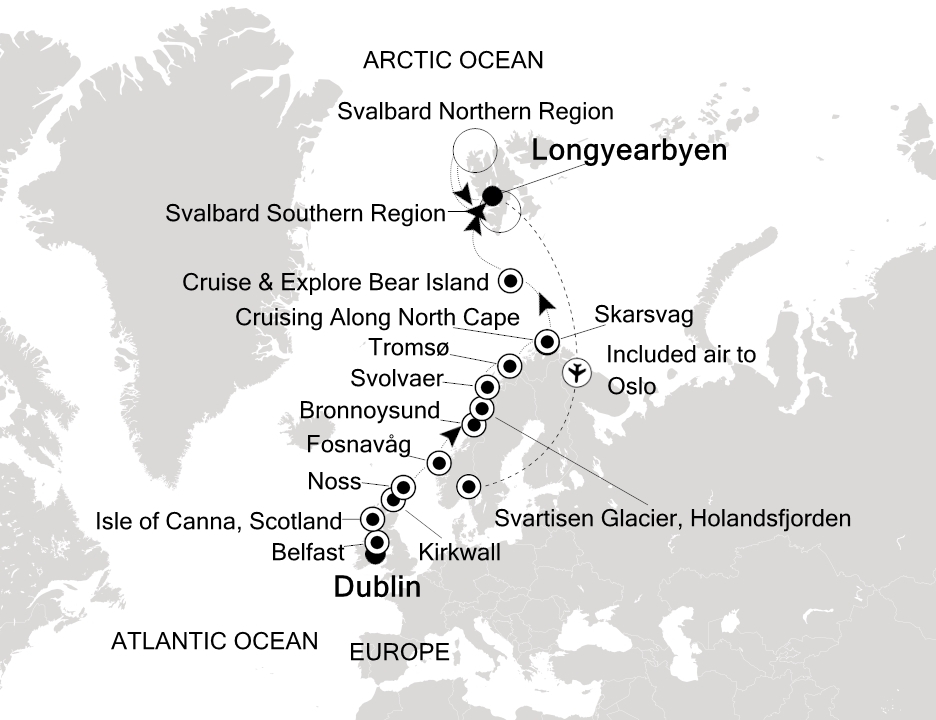
A 18-night expedition voyage aboard Silver Endeavour, Dublin, Ireland to Longyearbyen, Norway. Destination: Arctic and Greenland.
Operated by Silversea Cruises aboard Silver Endeavour.
Dublin
Belfast
Isle of Canna, Scotland
Lerwick, Shetland Islands, Scotland
Noss, Scotland
Fosnavåg
Bronnoysund
Svartisen Glacier, Holandsfjorden
Svolvaer
Tromsø
Skarsvag (Nordkapp)
Cruise & Explore Bear Island (Svalbard)
Svalbard Southern Region
Svalbard Northern Region
Longyearbyen
Atmospheric cobbled streets with buskers scraping fiddles and characterful pubs inviting passersby inside is Dublin in a snapshot. Horse-drawn carriages plod along cobbled centuries-old streets blending with an easy-going cosmopolitan outlook. Known for its fun-filled gathering of pubs any excuse works to enjoy a celebratory toast and chat among good company. Home to perhaps the world's most famous beer - slurp perfect pourings of thick dark Guinness - cranked out for the city's thirsty punters. Learn more of the humble pint's journey at the Guinness Storehouse. Dublin has come along way since the Vikings established a trading port here back in the 9th Century. In the time since the city became the British Empire's defacto second city and the Georgian imprint still adds oodles of historic character. Learn of 1916's Easter Uprising when the Irish rebelled and established their independence here as you visit the infamous haunting Kilmainham Gaol. The uprising's leaders were tried and executed in these dark confines. Dublin's St. Patrick's Cathedral has immense history below its steep spire which dates back to 1191. There's rich literary heritage to leaf through too and the city's streets were rendered vividly in James Joyce's classic Ullyses. The Museum of Literature celebrates the full scope of Dublin's lyrical talents. Trinity College also has a prestigious roll-call of alumni - visit to see the Book of Kells a beautifully illustrated bible of the medieval era.
Reborn as a cool modern city Belfast has successfully left its troubles behind emerging as a hotbed of culture and architecture where the comfort of a cosy pub is never far away. A walk across the Lagan Weir Footbridge brings you to Belfast’s fascinating Titanic District – an area of the city devoted to its rich ship-building heritage. The state-of-the-art Titanic Museum brings the story of the doomed vessel to life and is the largest museum dedicated to the infamously ‘unsinkable’ ship. There’s just enough time to give the 10-metre long Salmon of Knowledge sculpture a quick peck for luck before continuing to explore. A stark barbed wire and graffitied sheet metal barrier marks an abrupt scar through the city’s residential areas. The Peace Line was constructed during the height of the Troubles when Belfast was plagued by sectarian divisions between Protestants and Catholics. Nowadays you can jump in a black taxi tour to see the colourful murals and living history of the walls which stand as a stark reminder of the fragility of peace. After exploring the city’s historic divisions a reminder of Belfast’s uniting creativity can be found at the Metropolitan Arts Centre – a seven-storey tall building which invites light to gloriously cascade inside. The Cathedral Quarter is a cobbled blend of flower-adorned pubs restaurants and theatres and venues where music spills out onto the streets at night and many a pint is cheerily shared.
Many different groups of people have lived on the small Canna Isle. Neolithic people settled thousands of years ago. Later, Christian Celtic monks, Norse settlers and various Scottish groups lived on Canna. Evidence of most are still present, notably stone churches. One unusual relic is a standing stone with a hole above people’s heads in which the thumb of a lawbreaker was jammed. The accused was left for a time to reflect on his or her deeds. Canna is one of the Little Isles group of the Inner Hebrides. A bridge connects it to the adjacent Sanday Island. Both islands are small, with a tiny resident population. Today, the island is managed by the National Trust of Scotland. Compass Hill, 139 metres (456 feet) high, is a prominent landmark. It is named after the high iron content of the tuff—consolidated volcanic ash—makes up the hill. This attracted the needles of compasses on nearby ships causing confusion to pre-satellite navigators. The hill slopes have a variety of wildflowers that take advantage of good soils, and warm springs and summers. Canna is a bird sanctuary, with 15,000 breeding seabirds of 14 species. Half of the birds are Common Guillemots who nest on cliff ledges. A long-term National Trust bird ringing study has found guillemots live for a long time, with the oldest ever recorded for Britain being a 38 -year-old bird on Canne. As well as abundant seabirds, we may see scarcer birds including birds of prey. The majestic White-tailed Sea-eagle is one to look out for.
Adrift between the Scottish and Norwegian coasts the craggy Shetland Islands form the most northerly point of the British Isles. Sprawling across 100 islands connected by sandy bridges and crisscrossing ferries explore the highlights of this scenic archipelago outpost. Look out over dramatic coastline from atmospheric Iron Age towers. Sweeping windswept beaches and wisps of sand connect islands and rugged cliffs - stand back as the sounds of the waves smashing against the shore and calling gulls fills the air. The islands are also home to some of the most adorable four-legged creatures you’ll ever meet the diminutive and wavy-fringed Shetland Ponies who roam the hills and reach a maximum size of 42 inches. Don't be fooled though they are amongst the strongest and toughest of all breeds. Their existence here points to Viking history as local horses bred with ponies brought ashore by Norse settlers creating the lovable crossbreed that is an icon of these islands today. The towering Broch of Mousa is perhaps Europe’s best-preserved Iron Age building - and one of the Shetland's finest brochs - a series of round stone towers believed to have been constructed around 100 BC. Seals and birdlife ensure that the isolated islands are always well-populated with life - and you can embark on hikes to discover their coastal homes. Lerwick is the islands’ capital and there's a charming welcome on offer as you arrive before the waterfront of stone buildings which cascade down to the shore.
Exploring the sandstone cliff faces of the Isle of Noss will reveal ledges loaded with gannets puffins guillemots shags kittiwakes Razorbills fulmars and Great Skuas. The island was recognized as a National Nature Reserve in 1955 and has one of Europe’s largest and most diverse seabird colonies. Sheep have grazed the inland hillsides of Noss since the late 1800s and early 1900s when around twenty people lived on the island to manage the sheep farm. Along with the sheep shaggy Shetland ponies graze the windblown slopes of Noss.
Norway’s advertising slogan is that it is “powered by nature”. One trip to Bronnoysund and it’s easy to see why. This is quintessential Norway, vast, wild and beautiful, with a few surprises to keep you on your toes! Arrival by sea in Bronnoysund is a bit of an experience. Norway is famously the land of the midnight sun, and with Bronnoysund enjoying the favourable position of being just beneath the Arctic Circle, early morning arrival is both eerie and awe inspiring. The otherworldliness is amplified by the sun shining through the giant hole in Torghatten Mountain. The vast (258 metre) granite mountain is pierced right through centre by a natural hole. Never forgetting that Norway is the country of pixies and trolls, local legend has the answer to this scientifically unexplainable phenomenon: it was created when an arrow ripped through the troll king’s hat, which was thrown into the air to protect a fleeing girl. The hat turned to stone, and the arrow’s hole is preserved there to this day. It is possible to walk through it and enjoy the fabulous views beyond. The rest of Bronnoysund’s surroundings are no less spectacular. The 13,000-plus nearby islands include the Vega Archipelago, a cluster of 6,500 islands that enjoy UNESCO World Heritage Site status. The outstanding universal value of the islands is seen not only in stone age indications but in the unique cultural landscape (particularly that of Eider duck farming) that has provided at least 1,500 islanders with income from the 9th century.
Salt and pepper coloured mountains erupt from the ground behind the pretty port of Svolvaer, which opens up the extraordinary beauty of the Lofoten Islands. You'll never quite get over the majesty of the mountainous backdrop as you explore, although with natural wonders like the rippling Northern Lights, the Midnight Sun, and cruising pods of orcas to admire, there are plenty of distractions. The Gulf Stream shuffles warmer air here, so the climate is surprisingly mild considering how northerly the town is. Wander the compact streets, to see the morning's haul of fish and shrimp on-sale in the harbour, and watch sightseeing boats heading off to some of Norway’s most incredible natural scenery. Exploring Svolvaer Fantastically positioned for exploring the Lofoten peninsular, take a boat journey beside stacked mountains, and negotiate narrow fjords like Trollfjord, as you sail below circling eagles, and cloud-shrouded peaks. In winter, the mountain tips are silhouetted by rippling emerald colours, as dramatic Northern Light displays unfurl, while summer illuminates them with the Midnight Sun’s late burn. If you're feeling adventurous, head out to kayak between scattered islands, haul whopping catches from the glassy waters, or hike mountains like Tjeldbergtind – from which you can look down over the town, and see islands rising from the water like teeth. A little island hopping will take you to Haukland Beach, where gleaming white sand waits, and a blissful emerald ocean laps ashore poetically. Relax on the sand, or wander the dazzling coastline. You'll also be well located for a visit to the Lofotr Viking Museum, where you can see the rippling masts of sailing Viking ships, and the huge wooden longhouse that’s been constructed there. You’ll find what’s perhaps the region’s most immersive museum back in Svolvaer, however. The Lofoten War Museum is a jumbled, but utterly fascinating, treasure-trove of equipment, weaponry and World War II memorabilia. Learn about the role Norway played in the conflict, as you see everything from Nazi Christmas baubles, to a painting and drawings of Disney characters - apparently created by Hitler himself. For art, the KaviarFactory is a striking modern gallery, set in a former fishing warehouse. Its coastal location, and spacious whitewash interior, provides a fittingly spectacular exhibition space for evocative sculptures. The Magic Ice bar, meanwhile, is the place to enjoy a truly refreshing drink – sipped straight from a glass crafted from ice. Enter this sub-zero world of sculpture, where everything from the bar, to the reindeer statues that are dotted around, are hand hewn from huge chunks of thick ice.
Located in the far north of Norway a visit to Tromso beckons you to the extremes of this magical country to explore a fairytale land of jagged mountains glistening glaciers and husky-pulled sledges. Despite its remote location you'll discover a perhaps surprisingly cosmopolitan city with a healthy student population injecting plenty of energy. Sat 250 miles above the Arctic Circle - at 69° north - you can bathe in the midnight sun's glow during summer before winter brings the thick blackness and starry skies of endless polar nights. The darkness doesn't stop the fun - with a polar night half-marathon taking place in January - but the return of the sun is always a reason for a celebration here. To get the best view over the city take the cable car to Storsteinen's amazing viewpoint. Magnificent views down over the city fjord and Tromso's arching bridge will unravel before you. Learn more about northerly traditions polar expeditions and arctic hunting at the Polar Museum. The Science Centre meanwhile explains how humans have harnessed and survived these epic landscapes over the years and explores Tromso's breathtaking natural spectacle - the northern lights. The city is famed for its extraordinary viewing opportunities which are often said to be the best in the world. The Alpine Botanic Garden is the most northern such garden on the planet showcasing some of Norway's hardiest plantlife which survives and thrives at this nose-bleeding altitude.
For those who like to travel far (very far) off the beaten track, then you have found your Nordic nirvana in Skarsvag. Large, sparsely populated (there are just 60 human year round residents), and a joy to all those who revel in stark, unbridled beauty, Skarsvag also enjoys the auspicious title of being the world’s most northerly fishing village. But rolling hills, prolific birdlife and arctic fjords aside, Skarsvag is above all famous for its proximity to the North Cape. Found on the island of Magerøya, the most northernmost point of Europe above the arctic circle is a bucket list basic. Stand beneath the massive metal globe and gaze out onto the Barents Sea, where the only land between you and the North Pole is the Svalbard archipelago. This is truly the land of the midnight sun – in fact, you are so far north that the sun doesn’t even dip beneath the horizon between May and mid-July. The island’s famous bird cliffs are quite spectacular, and home to thousands of puffins, gannets and cormorants. Those willing to hike to cape Knivskjellodden, the northernmost point on Magerøya, will be rewarded with stunning cliff face views of the North Cape Plateau. Before leaving, head into the impressive North Cape Hall for exhibitions on the North Cape’s history. Travellers have been visiting since 1664, when Italian priest Francesco Negri arrived, so there are some tales to tell! More intriguingly, a tunnel has been hewn into the rock, leading down to the cliff face, complete with a chapel.
Situated at the very north tip of Norway and inside the Arctic Circle, there is something very special about being (almost) at the top of the world. Called the northernmost point of Europe, the North Cape (Nordkapp in Norwegian) lies about 1,306.3 mi from the North Pole, with no dry land between except for the Svalbald archipelago. Home to where the Atlantic and Arctic oceans meet, this is the true land of the midnight sun – constant spectacular scenic views and 24-hour sunlight lends itself to a sense of giddy informality aboard. Just imagine sipping a chilled glass of champagne at the very top of the world in full daylight at midnight – sensational. Be sure to be on the lookout for hundreds of thousands of puffins, gannets, cormorants, seals, dolphins and whales that make this stretch of chilly water their home. Not forgetting the colourful, compact fishing villages, so at odds with the otherwise this stark, barren landscape.
Bear Island is considered Svalbard’s southernmost island, roughly half way between Spitsbergen and Norway’s North Cape. Although the last polar bears were seen in 2004, the name goes back to Dutch explorer Willem Barentsz and his visit in 1596. The island has been used to hunt walrus, for whaling, and even coal mining has taken place. The strategic location on the border of the Norwegian Sea and the Barents Sea has led to a meteorological station being set up by Norway near Gravodden on Bear Island’s north coast. Some two thirds of the island is a relatively flat plain with shallow freshwater lakes and Ramsar Wetland, while the entire island and the surrounding waters are a Nature Reserve. Bear Island has also been designated an Import Bird Area as it is a staging area for Pink-footed and Barnacle Geese and the steep cliffs south of Sørhamna are home to thousands of breeding seabirds. This is a specially protected area where Zodiacs are allowed to cruise along the cliffs around Kapp Kolthoff. In smaller amounts Atlantic Puffins, Northern Gannets, Glaucous Gulls and Great Skuas are found in between the large Black-legged Kittiwake, Little Auk, Common Guillemot and Brünnich’s Guillemot colonies. The constant battering of the sea has not only created impressive sea caves and tunnels, but unfortunately the Russian vessel Petrozavodsk shipwrecked near Revdalen at the base of the limestone cliffs and the waves are causing a continuous disintegration of the remains of the ship.
Svalbard’s Southern Region and specifically Spitsbergen’s west coast is less ice-clogged than the rest of Svalbard due to the moderating influenced of the Gulf Stream. Several fjords cut into the western coast of Spitsbergen and have been used by trappers and hunters as well as the different mining companies that tried to exploit the riches of the archipelago’s largest island of Spitsbergen. Remains of huts and mines as well as active commercial and scientific settlements can be found and visited. Depending on the time of the season glaciers can be visited on foot or by sea. Northern places like Magdalenefjorden and Hornsund will reveal fascinating views of geological formations craggy mountains spectacular glaciers and a variety of seabirds and seals.
Svalbard’s Southern Region and specifically Spitsbergen’s west coast is less ice-clogged than the rest of Svalbard due to the moderating influenced of the Gulf Stream. Several fjords cut into the western coast of Spitsbergen and have been used by trappers and hunters as well as the different mining companies that tried to exploit the riches of the archipelago’s largest island of Spitsbergen. Remains of huts and mines as well as active commercial and scientific settlements can be found and visited. Depending on the time of the season glaciers can be visited on foot or by sea. Northern places like Magdalenefjorden and Hornsund will reveal fascinating views of geological formations craggy mountains spectacular glaciers and a variety of seabirds and seals.
Svalbard’s northern region is less influenced by the Norwegian Current coming through the Greenland Sea than the southern region and shows more ice. The northern part of the island of Spitsbergen shows quite a number of impressive fjords, bays and glaciers. The Nordaust Svalbard Nature Reserve includes Spitsbergen’s east coast, the Hinlopen Strait, Nordaustlandet and some islands further east like Kvitoya and Storoya. Several walrus haul-outs, spectacular glaciers, bird cliffs and bird islands, as well as surprising flora in Arctic deserts and the possibility to see polar bears and to visit historically important sites make this an area prone for exploration. Ice conditions will dictate which sites can be seen.
Svalbard’s northern region is less influenced by the Norwegian Current coming through the Greenland Sea than the southern region and shows more ice. The northern part of the island of Spitsbergen shows quite a number of impressive fjords, bays and glaciers. The Nordaust Svalbard Nature Reserve includes Spitsbergen’s east coast, the Hinlopen Strait, Nordaustlandet and some islands further east like Kvitoya and Storoya. Several walrus haul-outs, spectacular glaciers, bird cliffs and bird islands, as well as surprising flora in Arctic deserts and the possibility to see polar bears and to visit historically important sites make this an area prone for exploration. Ice conditions will dictate which sites can be seen.
Svalbard’s northern region is less influenced by the Norwegian Current coming through the Greenland Sea than the southern region and shows more ice. The northern part of the island of Spitsbergen shows quite a number of impressive fjords, bays and glaciers. The Nordaust Svalbard Nature Reserve includes Spitsbergen’s east coast, the Hinlopen Strait, Nordaustlandet and some islands further east like Kvitoya and Storoya. Several walrus haul-outs, spectacular glaciers, bird cliffs and bird islands, as well as surprising flora in Arctic deserts and the possibility to see polar bears and to visit historically important sites make this an area prone for exploration. Ice conditions will dictate which sites can be seen.
Svalbard’s northern region is less influenced by the Norwegian Current coming through the Greenland Sea than the southern region and shows more ice. The northern part of the island of Spitsbergen shows quite a number of impressive fjords, bays and glaciers. The Nordaust Svalbard Nature Reserve includes Spitsbergen’s east coast, the Hinlopen Strait, Nordaustlandet and some islands further east like Kvitoya and Storoya. Several walrus haul-outs, spectacular glaciers, bird cliffs and bird islands, as well as surprising flora in Arctic deserts and the possibility to see polar bears and to visit historically important sites make this an area prone for exploration. Ice conditions will dictate which sites can be seen.
Longyearbyen is the biggest settlement in Svalbard. Seat of the Norwegian administration it also has the best services and infrastructure in the archipelago. Located deep in the Adventfjord a sidearm of the Isfjorden (Icefjord) Longyearbyen’s airport can be used all-year round but its harbor is blocked by ice in winter. Most shops hotels restaurants and a hospital are within easy walking distance of the port. One of the most prominent buildings in town is the UNIS center where several Norwegian universities have joined forces to operate and offer the northernmost higher education to both Norwegian and international students. Adjacent to UNIS and well worth a visit is the Svalbard Museum covering the natural history and exploitation of Svalbard. Remnants of the former mining activity can be seen all around Longyearbyen and even in town.
From $31,050
per guest · 18 nights
Prices are a guide and vary with season, cabin category and party size. Your advisor will confirm the exact cost before anything is booked.
Classic Veranda
suite
Deluxe Veranda
suite
Grand 1 Bedroom
suite
Owner 1 Bedroom
suite
Premium Veranda
suite
Silver
suite
Superior Veranda
suite